Solutions
Advanced generative design technology that transforms how infrastructure projects are planned, evaluated, and optimized for maximum efficiency and sustainability.
L.IN.E.A is the Infraspace AI engine that explores thousands of alignment alternatives against terrain, constraints, and KPIs. Product · What is L.IN.E.A?
Use Cases
From ideas to decisions in seconds
Create
Based on your cost inputs, geometric constraints, and geospatial data, our generative software can provide you with several alternatives in just minutes.
Evaluate
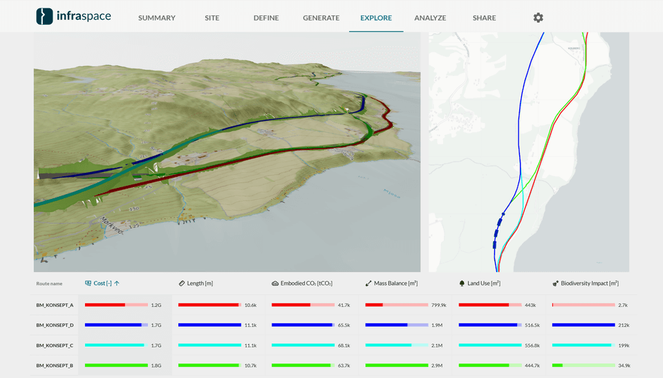
Upload your proposed alignments to our cloud-based platform and receive instant evaluations and visualizations with 3D models and KPI Dashboards.
Optimize
Optimize your proposals within the constraints of your projects. Use your proposal as a basis and leverage our generative algorithms to quickly explore potential cost savings or reduced environmental impact.
Roads & Highways
Optimize highway alignments, minimize environmental impact, and reduce construction costs for road infrastructure projects. Our advanced algorithms analyze terrain, traffic patterns, and environmental factors to create the most efficient routing solutions.
Railways
Design efficient railway corridors with automated gradient analysis and curve optimization.
Power Lines
Plan transmission line routes with terrain analysis and tower placement optimization.
Onshore Wind Farms
Design wind farm access roads and optimize your hardstands based on earthworks and geometrical constraints.
Industrial Sites
Find optimal sites for flat industrial sites—minimizing earthworks and construction costs.
Designed for transparency
Web-based projects enable all stakeholders to easily access design alternatives and stay informed. With intuitive data visualization, understanding the premise of your infrastructure becomes effortless.
Solutions FAQ
How generative design and optioneering apply across infrastructure sectors.
Which infrastructure types can Infraspace support?
Infraspace can support roads, railways, networks of access roads, power transmission lines and industrial site location studies.
The platform is strongest when several alternatives must be considered and terrain, land take, earthworks, or environmental impact matter.
- Roads and highways
- Railways
- Power transmission lines
- Pipelines
- Wind farm access roads
- Industrial site location studies
What is generative design in infrastructure planning?
Generative design is a method where algorithms automatically generate infrastructure alternatives based on defined objectives and constraints.
In infrastructure planning, this can include geometric rules, terrain, environmental restrictions, cost targets, land-use requirements, and CO2 objectives.
What problems does Infraspace solve?
Infraspace reduces the manual effort of exploring infrastructure alternatives. With shared KPIs and 3D visualizations, teams can compare concepts on equal footing and move faster from idea to decision. With estimates of earthworks quantities, construction cost and environmental impact, teams can make stronger early-stage choices.
What is AI-assisted infrastructure optioneering?
AI-assisted optioneering is the process of using AI and geospatial analysis to generate, evaluate, and compare many infrastructure alternatives.
It allows planners to move beyond a few manually created concepts and explore a wider solution space earlier in the project.
What is corridor optimization?
Corridor optimization is the process of finding the most suitable route or corridor for infrastructure such as roads, railways, pipelines, or power lines.
It considers terrain, geometry, environmental constraints, land use, cost, CO2, and constructability.
How does Infraspace work?
Users define a project area, add relevant GIS and terrain data, configure infrastructure definitions, and either sketch, upload, or generate alignment proposals.
Infraspace then analyzes proposals with KPIs such as cost, CO2, earthworks, mass balance, land use, and environmental impact.
Learn more
How do teams collaborate in Infraspace?
Infraspace is a web-based platform where project data, proposals, 3D models, and analysis results are available to authorized users.
This supports collaboration between disciplines and stakeholders without requiring everyone to use desktop engineering software.