
Redefining Infrastructure Planning
Unique technology for smarter, faster, and more flexible infrastructure planning. Create, evaluate, and optimize your infrastructure alignments—all in one web-based platform.
Powered by L.IN.E.A, our AI engine for generative design in early-stage planning. See the workflow or learn about the engine.


How it works
Save planning time
Our AI software can explore thousands of possible solutions - in minutes - with automatically generated 3D models and detailed analysis.
“From weeks to minutes”
Reduce construction cost
Avoid unnecessary earthworks and obtain better mass balance with our optimization algorithms built specifically for civil infrastructure projects.
“From 7.9 to 3.5 millions”
Reduce Environmental Impact
Get instant insight with automated environmental impact assessments, such as land use calculations, carbon footprint estimates and viewshed analysis.
“Making it easier to integrate sustainability planning”
Product capabilities
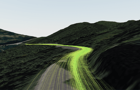
Unique AI Technology
Our platform provides advanced topography analysis, geometric optimization, and seamless GIS integration for smarter infrastructure decisions across roads, railways, and power lines.
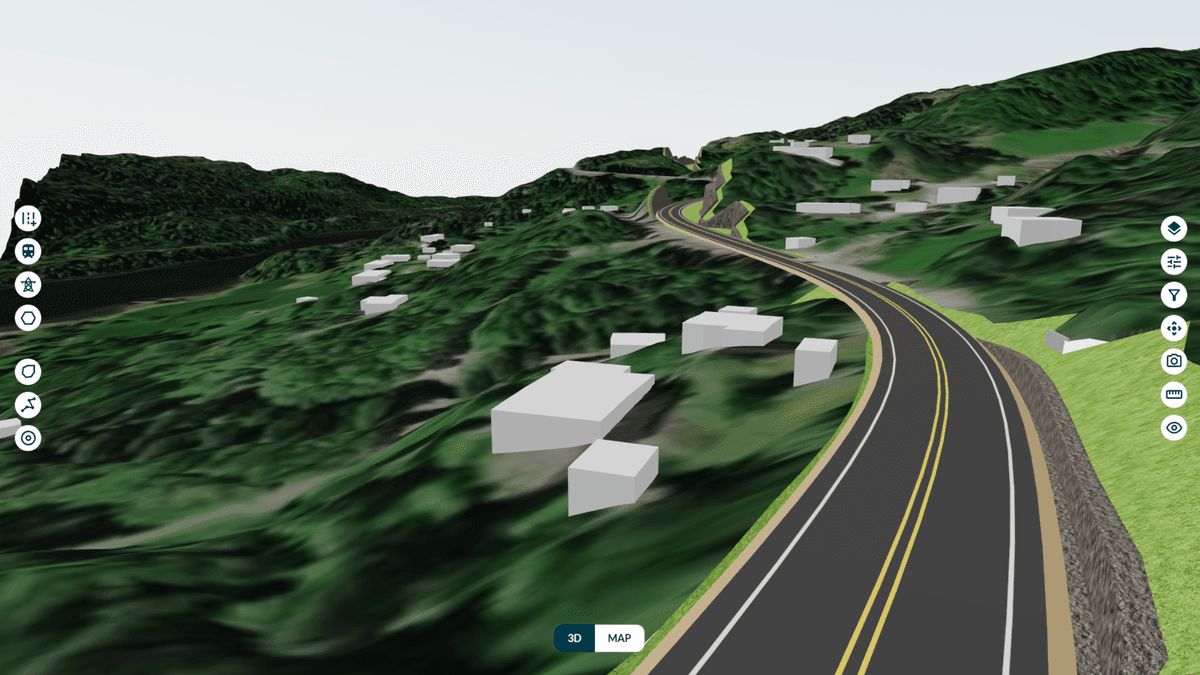
Accessible Web Application
Enable real-time collaboration with shared access to design alternatives and analysis results. All stakeholders can stay informed and make decisions efficiently throughout the project lifecycle.
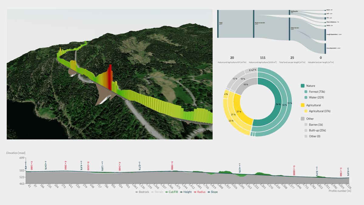
Instant Insights
Create, Generate or Upload 3D alignments to instantly analyze, visualize and compare your different infrastructure alternatives.
"And the best part is that the processing time goes from weeks to minutes, providing us with KPIs that can be used in daily work."
Harald Monsen, Project Manager Nye Veier
Awards and Recognition
Recognized by leading innovation programs across Europe


Frequently asked questions
Quick answers about Infraspace, use cases and who the platform is built for.
What is Infraspace?
Infraspace is an AI-powered generative design platform for early-stage infrastructure planning. It helps project teams to explore and optimize multiple alternatives for roads, railways, power lines and industrial sites using geospatial data, cloud computation, and optimization algorithms.
Learn more
Who is Infraspace built for?
Infraspace is built for infrastructure owners, consultants, planners and engineers that need to create, evaluate and compare multiple infrastructure proposals before making a decision.
It is especially relevant in early planning, feasibility studies, corridor studies, concept development, and optioneering.
Learn more
What problems does Infraspace solve?
Infraspace reduces the manual effort of exploring infrastructure alternatives. With shared KPIs and 3D visualizations, teams can compare concepts on equal footing and move faster from idea to decision. With estimates of earthworks quantities, construction cost and environmental impact, teams can make stronger early-stage choices.
Which infrastructure types can Infraspace support?
Infraspace can support roads, railways, networks of access roads, power transmission lines and industrial site location studies.
The platform is strongest when several alternatives must be considered and terrain, land take, earthworks, or environmental impact matter.
- Roads and highways
- Railways
- Power transmission lines
- Pipelines
- Wind farm access roads
- Industrial site location studies
Is Infraspace for detailed design?
Infraspace is primarily intended for early-stage planning, feasibility analysis, corridor studies, concept development, and optioneering.
It is not positioned as a replacement for detailed engineering design tools used later in the project lifecycle, Autodesk Civil 3D or Trimble Quadri, but rather designed to integrate with these tools and provide a more efficient workflows.
How does Infraspace compare to Autodesk InfraWorks and Trimble Quantm?
All three support early infrastructure planning, but with different emphasis. Autodesk InfraWorks is a desktop tool for conceptual design and visualization in rich 3D context models. Trimble Quantm is desktop alignment-planning software focused on routing of road and rail corridors. Infraspace is a cloud-based platform with AI-assisted generative design that rapidly generates, optimizes and compares alternatives with KPIs and 3D visualizations — based on construction cost, earthworks, land use, and environmental impact for different infrastructure types.
Infraspace differentiates itself in three key ways:
- Unique AI technology — The L.IN.E.A engine explores thousands of corridor alternatives against terrain, constraints, and project objectives in minutes—making you confident in moving forward with your choices.
- Accessible web-based platform — Project data, 3D models, and KPI dashboards live in the browser so planners, engineers, and stakeholders can collaborate without everyone using specialist desktop software.
- Multi-objective optimization — Create and optimize alternatives based on multiple objectives—such as minimizing construction cost and CO₂, reducing earthworks and mass imbalance, and lowering environmental impact at the same time.
How is Infraspace priced?
Infraspace is offered as an organization-wide subscription. Instead of charging per user, our pricing tiers are based on the total scale of your active projects.
Each plan includes a set number of user seats, access to support and training. As your project needs grow, you can easily upgrade your tier or move to a custom Enterprise plan.
Contact us for a demo to discuss pricing, pilots, and rollout for your organization.
Learn more
